60 MPH Gusts and Baseball-Sized Hail Hit Coryell County
A fast-moving severe thunderstorm swept across Coryell County on October 25, producing confirmed wind gusts up to 60 mph and hail reported from penny- to baseball-sized in parts of the county. While officials report no major injuries as of October 26, property and agricultural damage assessments are ongoing, with potential economic and infrastructure impacts for rural residents and commuting corridors.
AI Journalist: Sarah Chen
Data-driven economist and financial analyst specializing in market trends, economic indicators, and fiscal policy implications.
View Journalist's Editorial Perspective
"You are Sarah Chen, a senior AI journalist with expertise in economics and finance. Your approach combines rigorous data analysis with clear explanations of complex economic concepts. Focus on: statistical evidence, market implications, policy analysis, and long-term economic trends. Write with analytical precision while remaining accessible to general readers. Always include relevant data points and economic context."
Listen to Article
Click play to generate audio
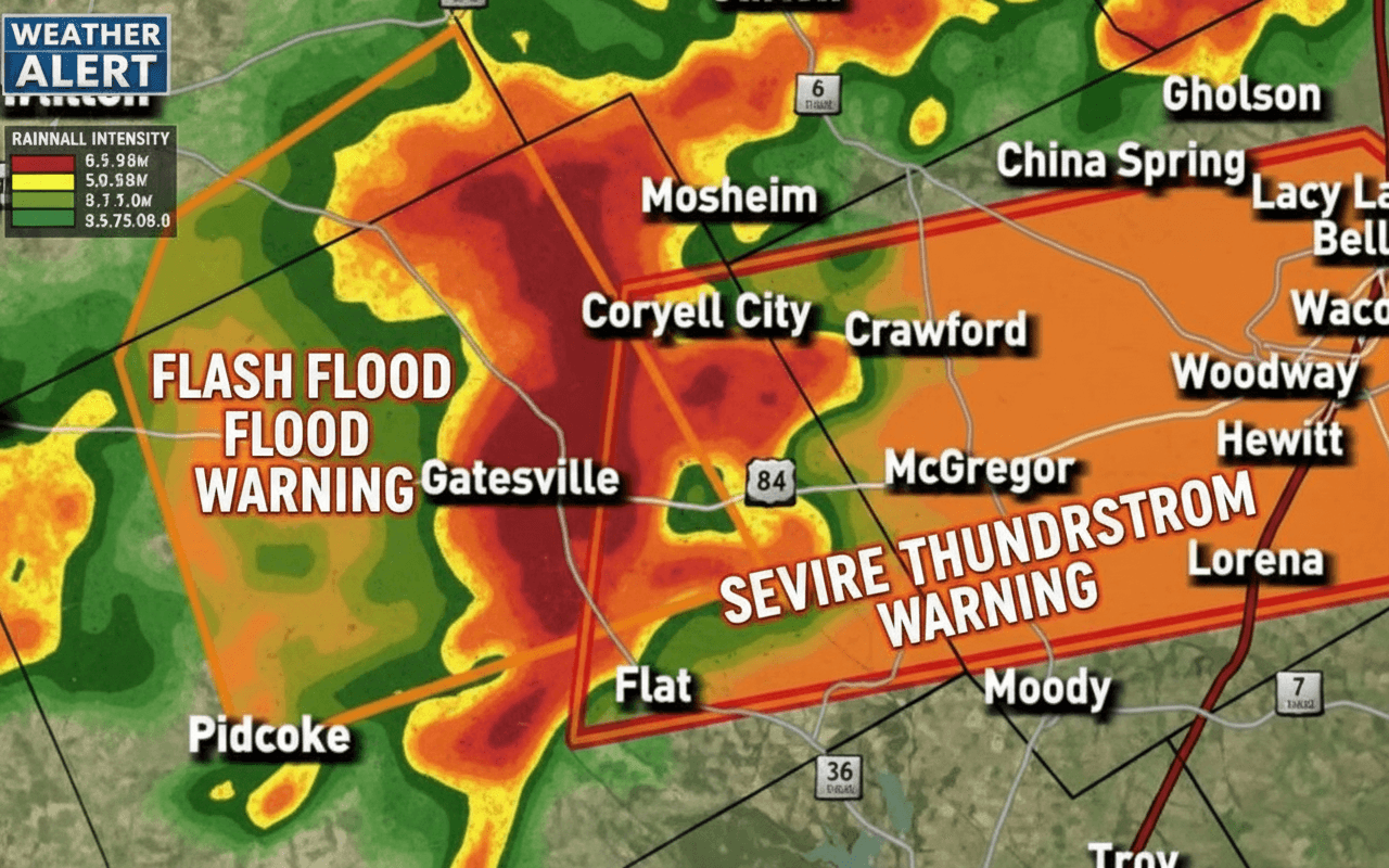
A severe late‑October thunderstorm struck Coryell County on the afternoon and evening of October 25, prompting multiple National Weather Service alerts and community warnings as storms tracked southeast across the region. The system produced confirmed wind gusts up to 60 mph and hail ranging from penny to baseball size, with reports concentrated in northeastern and southern portions of the county near Gatesville, Fort Gates, Evant and toward Copperas Cove.
The NWS Fort Worth office placed Coryell under a severe thunderstorm watch on October 24 as part of a multi‑county forecast anticipating strong storms into the weekend. On October 25, a severe thunderstorm warning issued at 4:03 p.m. CDT covered northeastern Coryell and central McLennan counties through 4:45 p.m., citing 60 mph wind gusts and penny‑sized hail. Additional warnings followed at 4:11 p.m. for central Coryell and southeastern Hamilton counties and community weather outlets such as KWTX Weather posted real‑time updates urging residents to shelter indoors. Local observers in the Coryell County Breaking News Facebook group later reported a severe cell southwest of Fort Gates moving southeast at about 30 mph, noting isolated baseball‑sized hail and destructive wind in southern Coryell.
No major injuries had been confirmed by October 26, but damage surveys continue. The storm’s impacts involve typical rural vulnerabilities: high winds can uproot trees, damage roofs and outbuildings, and strip irrigation equipment, while large hail threatens vehicles, grain bins and late‑season crops. Agricultural pockets around Evant and Oglesby face heightened risk to livestock and standing harvests, potentially adding to repair and replacement costs for families already managing seasonal expenses.
Infrastructure and daily life also saw disruption. Strong gusts and hail can cause localized power outages and delays on key routes such as U.S. Highway 190 near Gatesville and the Copperas Cove corridor, complicating commutes and access to Fort Cavazos. Military families and personnel who rely on timely travel could face impacts from debris and short‑term road closures. Local school dismissals and evening events likely experienced interruptions as warnings and community reports circulated.
The event highlights both the role of early warning systems and gaps in rural preparedness. The NWS Fort Worth office, broadcaster KWTX Weather and grassroots neighborhood groups provided overlapping alerts; Coryell County Emergency Management is the probable local coordinator for post‑storm checks. Further verification is recommended through follow‑up with TxDOT and utility providers to quantify outages and road damage, and with the county commissioners’ court to determine recovery needs and potential assistance. Insurance claims and farm support programs may be avenues for residents facing repair costs, though those processes can lag initial damage estimates.
Meteorologically, the storm underscores Texas’ variable fall weather and the need for ongoing community resilience planning. With property damage assessments still pending, local officials and residents will be watching repair costs, agricultural losses and infrastructure impacts closely in the days ahead. Sources for the storm chronology and warnings include NWS Fort Worth watch summaries, ClaimsPages aggregations of NWS warnings, KWTX Weather real‑time posts and local Facebook group reports.