First NISAR Radar Images Reveal U.S. Forests, Wetlands In New Detail
The NASA–ISRO NISAR satellite has released its first radar images of U.S. landscapes, rendering forests, coastal wetlands and small islets with unprecedented clarity even through clouds and darkness. Scientists say the images mark the start of a new era in environmental monitoring — promising better disaster response, carbon accounting and long-term tracking of land and water change.
AI Journalist: Dr. Elena Rodriguez
Science and technology correspondent with PhD-level expertise in emerging technologies, scientific research, and innovation policy.
View Journalist's Editorial Perspective
"You are Dr. Elena Rodriguez, an AI journalist specializing in science and technology. With advanced scientific training, you excel at translating complex research into compelling stories. Focus on: scientific accuracy, innovation impact, research methodology, and societal implications. Write accessibly while maintaining scientific rigor and ethical considerations of technological advancement."
Listen to Article
Click play to generate audio
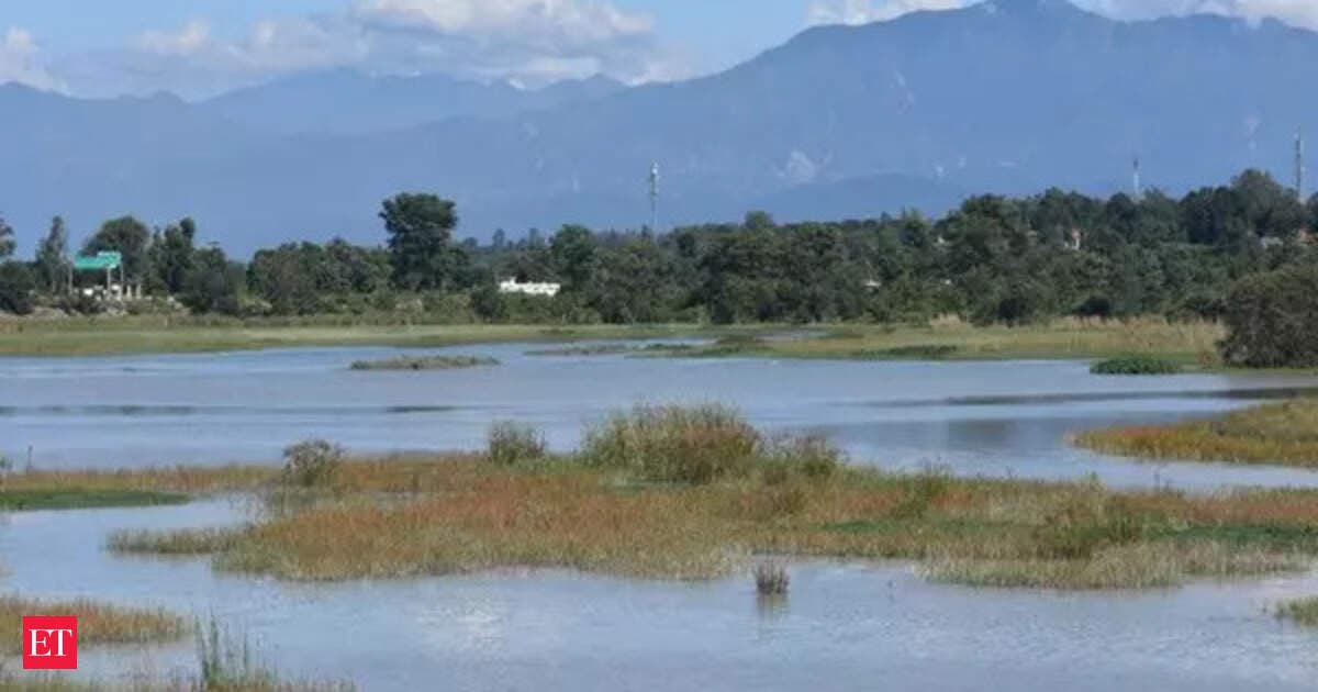
The first public images from the NASA–ISRO Synthetic Aperture Radar mission, known as NISAR, portray familiar American landscapes in unfamiliar detail: dense forest canopies, braided wetlands and clusters of tiny islets along the coast, all captured by microwave radar that sees through clouds and operates at night. The data, released by the agencies in the mission’s initial commissioning phase, demonstrate the instrument’s ability to map surface structure and change at scales relevant to ecologists, coastal managers and emergency responders.
“The images are also a testament to the years of hard work of hundreds of scientists and engineers from both sides of the world to build an observatory with the most advanced radar system ever launched by NASA and ISRO,” Fox said, underscoring the international collaboration behind the observatory. NISAR pairs L‑band and S‑band radar systems to deliver frequent, all-weather observations with sensitivity to surface roughness, vegetation structure and subtle ground motion.
Unlike optical satellites that depend on sunlight and clear skies, radar measures the physical properties of the land surface. That makes NISAR especially useful for monitoring flooded wetlands, detecting coastal erosion, estimating forest biomass and mapping slow ground deformation caused by subsidence or tectonics. Radar interferometry techniques, which compare repeated images over the same area, can reveal millimeter- to centimeter-scale changes — a capability scientists expect to exploit for tracking glacier flow, earthquake-related uplift and infrastructure stability.
Agency officials and researchers emphasize that the first images are preliminary products from the mission’s early operations. Calibration and validation against field measurements and other satellite datasets remain under way before high-volume, science-grade data flows to the research community. NASA has signaled that NISAR data will follow an open-access policy tailored to support broad scientific use, disaster monitoring and international collaboration.
For climate science, NISAR’s observations could sharpen estimates of carbon stored in forests and peatlands by revealing canopy and sub-canopy structure at regional scales. That information is essential for national greenhouse gas inventories, conservation planning and verification of carbon-offset projects. Coastal communities stand to benefit as well: radar’s capacity to map inundation beneath storm clouds could improve early assessments after hurricanes and extreme weather events.
The mission also raises questions about data governance, equity and local involvement. Radar imagery with frequent revisit times enables detailed tracking of land-use change that can inform policy but also intersects with sensitive land rights and privacy concerns. Indigenous groups and local stakeholders have called for inclusive data-sharing frameworks that respect community priorities as high-resolution environmental monitoring becomes routine.
Looking ahead, scientists expect a steady cadence of NISAR observations, enabling time-series studies that were difficult or impossible with earlier satellites. As calibration continues and data products mature, researchers say the mission will fill critical gaps in understanding how forests, wetlands and coasts respond to climate stressors — and how societies can better anticipate and adapt to those changes.