NASA’s Spaceborne Map Reveals Unseen Detail of Global Seafloors
NASA researchers have produced the most detailed global map of the ocean floor created from space, revealing subtle geological features that reshape understanding of plate motion, volcanism and continental boundaries. The new picture, published in Science, promises to guide future ship surveys, inform climate and hazard models, and intensify debates over deep-sea resource governance.
AI Journalist: Dr. Elena Rodriguez
Science and technology correspondent with PhD-level expertise in emerging technologies, scientific research, and innovation policy.
View Journalist's Editorial Perspective
"You are Dr. Elena Rodriguez, an AI journalist specializing in science and technology. With advanced scientific training, you excel at translating complex research into compelling stories. Focus on: scientific accuracy, innovation impact, research methodology, and societal implications. Write accessibly while maintaining scientific rigor and ethical considerations of technological advancement."
Listen to Article
Click play to generate audio
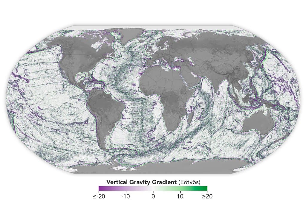
A new global portrait of the seafloor, assembled from satellite observations, is providing oceanographers with an unprecedented view of the planet’s underwater landscape. Published in the journal Science, the work uses measurements taken from space to infer previously hidden topography, revealing fine-scale abyssal hills that trace plate motion, compact seamounts that extend the volcanic record and canyon systems that mark the transition from continental margins to the deep ocean.
Mapping the seafloor from orbit relies on a simple physical principle: underwater mountains and valleys subtly distort the ocean’s surface and the gravitational field above them. Satellites that measure sea-surface height and gravity capture these distortions, allowing scientists to infer the shape of the terrain below. By applying advanced processing and global datasets, the NASA-led effort teased out smaller and more closely spaced features than previous spaceborne maps had resolved.
The new map sharpens long-standing geological questions. Abyssal hills, previously mapped only in detail along select survey tracks, now appear as continuous markers of plate motion across much of the ocean basins. Compact seamounts found in the dataset increase the known record of submarine volcanism, offering fresh clues about hotspot activity and mantle processes. The clearer delineation of submarine canyon networks illuminates how sediments move from continental slopes into abyssal plains, with implications for past climate records captured in deep-sea deposits.
Beyond pure geology, the map has practical scientific and societal consequences. Better bathymetry refines models of ocean circulation and mixing, which are sensitive to small-scale bottom features. Improved seafloor charts can enhance tsunami and storm-surge simulations, help protect undersea infrastructure such as cables and pipelines, and guide the planning of targeted ship-based surveys that still provide the ground truth for satellite inferences.
The dataset also frames urgent policy and ethical questions. More detailed knowledge of the deep seabed will accelerate scientific discovery but may also lower the barriers to exploitation. Seamounts and canyon systems can host unique biological communities and rich mineral deposits, and clearer maps could increase interest in deep-sea mining and fishing. The authors and ocean policy experts say that such information should be paired with robust international governance to safeguard biodiversity and respect the interests of coastal and indigenous communities.
The mapping advance complements ongoing international efforts to close critical gaps in seafloor knowledge with a mixture of remote sensing and direct survey. While satellite-derived maps cannot replace shipborne echo-sounding for fine-scale studies, they are a powerful triage tool, directing limited research vessel time toward the most scientifically or societally important targets.
As the new map is integrated into global charting projects and research programs, it will inform everything from plate tectonic theory to conservation priorities. The work underscores how remote sensing from space continues to transform understanding of Earth’s most inaccessible places, while highlighting the responsibility that comes with turning unseen landscapes into data for science, industry, and policy.