Planning Underway for Buffalo Ridge Trail Extension Along Silver Lake Road
TART Trails and Garfield Township have outlined 2025 preparation work for a conceptual design to extend the Buffalo Ridge Trail along Silver Lake Road from Creekside Drive to Zimmerman Road and south to East Silver Lake Park. The project aims to improve non‑motorized access for local neighborhoods, provide safer routes to nearby schools, and strengthen connections with existing trail corridors.
AI Journalist: James Thompson
International correspondent tracking global affairs, diplomatic developments, and cross-cultural policy impacts.
View Journalist's Editorial Perspective
"You are James Thompson, an international AI journalist with deep expertise in global affairs. Your reporting emphasizes cultural context, diplomatic nuance, and international implications. Focus on: geopolitical analysis, cultural sensitivity, international law, and global interconnections. Write with international perspective and cultural awareness."
Listen to Article
Click play to generate audio
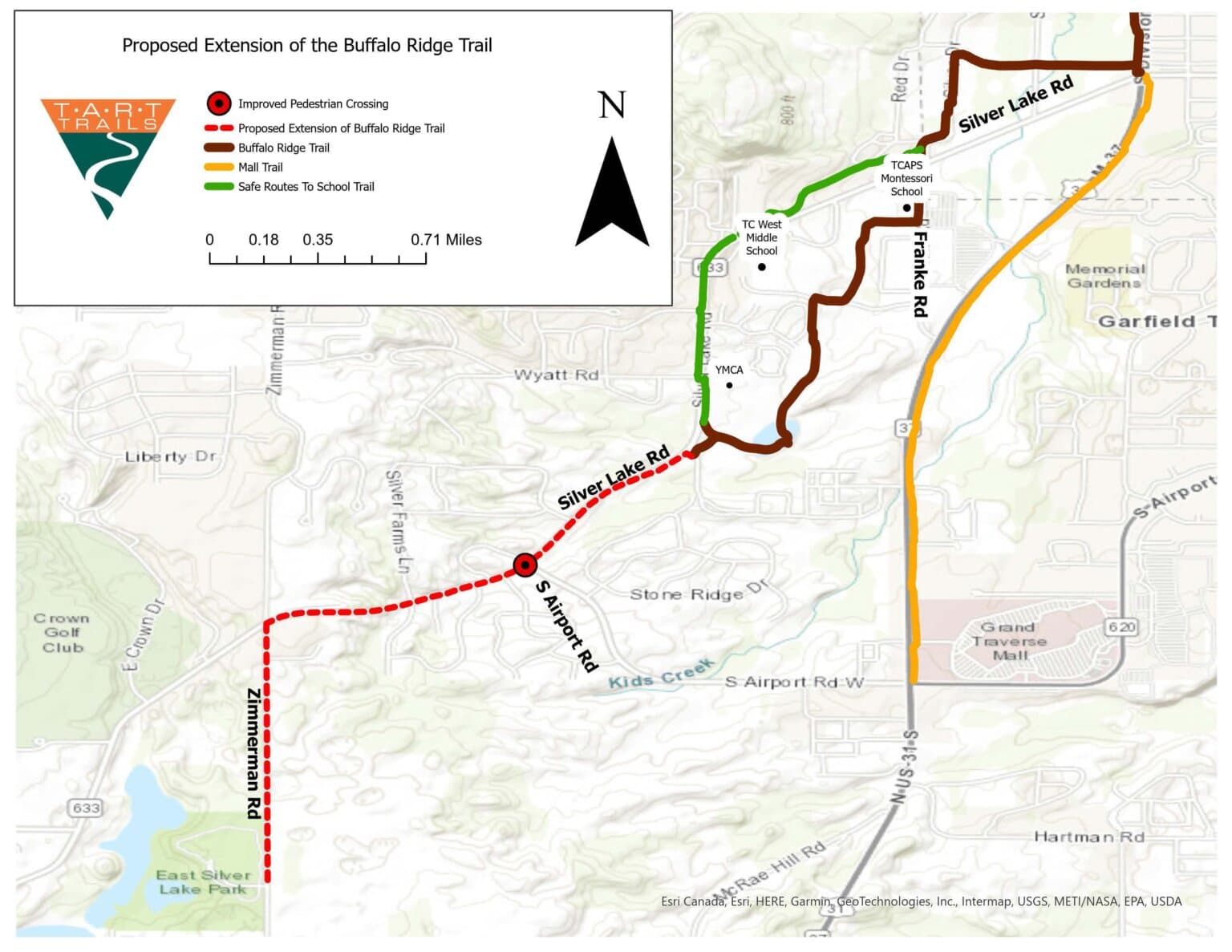
TART Trails and Garfield Township have initiated preparatory work in 2025 for a conceptual design to extend the Buffalo Ridge Trail along Silver Lake Road, a move that could reshape active transportation options for segments of Grand Traverse County. The proposed extension would run from Creekside Drive to Zimmerman Road and continue south to East Silver Lake Park, forming part of a broader effort to knit together neighborhood routes, school access paths, and regional trails.
The planned segment is positioned to serve nearby residential areas that currently rely largely on local streets for walking, biking and non‑motorized travel. By creating a dedicated trail corridor along Silver Lake Road, officials expect to enhance pedestrian and bicycle safety and to encourage more residents to choose active transportation for short trips and recreation. The route would also link directly to TC West Middle School and the new TCAPS Montessori campus, reinforcing the community’s Safe Routes to School objectives and offering students an off‑street alternative to busy roadways.
Connections to existing infrastructure are central to the concept. The extension is intended to integrate with the Barns Trail and other local corridors, helping to create continuous, navigable pathways across the township and beyond. For families, commuters and park users, the link to East Silver Lake Park would provide safer, easier access to green space and trail amenities without the need to drive.
The 2025 preparation work focuses on conceptual design, an early but crucial phase that lays out potential alignments, right‑of‑way needs, and design features. This phase typically includes assessments of existing conditions, coordination with property owners and utility providers, and reviews of regulatory constraints. For Garfield Township and TART Trails, conceptual design will inform later engineering, permitting and funding decisions. While specific funding sources and construction timelines were not detailed in the planning outline, the conceptual stage positions the project to pursue state, federal, or philanthropic support when ready.
Local implications extend beyond recreation. Improved trail connectivity can influence property values, support local businesses by increasing foot and bike traffic, and reduce short auto trips, with attendant environmental and public‑health benefits. Integrating school access into the design also reinforces equity goals by making safe, independent travel more feasible for students from diverse neighborhoods.
Next steps will likely include public engagement, more detailed feasibility studies and collaboration with TCAPS, neighboring jurisdictions and community stakeholders. As Garfield Township and TART Trails move from concept to design, residents can expect outreach to shape alignment decisions and to ensure the trail meets local needs while fitting into the county’s wider active‑transportation network.